Campus News
Watching the flow of water through oak woodlands at Arbor Creek Experimental Watershed
To understand how California’s beloved oak woodlands will fare in a rapidly warming climate, UCSC researchers are putting a headwaters stream in the Diablo Range under a hydrological microscope.
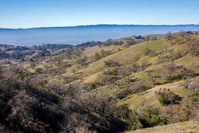
Foothill oak woodlands are among the most familiar ecosystems in California. Supporting deer and squirrels, acorn woodpeckers and oak moths, these habitats occupy tens of thousands of acres across the state. Yet change is coming to these widespread habitats. Like much of the West, California’s foothills are predicted to experience shifts in climate in coming decades. Shifts in the amount and timing of precipitation, together with warming weather, are likely to affect how fast local soils will erode, how much water is stored below ground, and even whether oaks can survive where they are found today.
To understand how these beloved woodlands will fare in a rapidly warming climate, UC Santa Cruz researchers are putting a headwaters stream in the Diablo Range under a hydrological microscope.
“Our globe has a finite amount of water. Once it rains, where does water go? How long does it stay in our hill slopes? And what controls how it leaves in streams and through plants?” asks Margaret Zimmer, a professor of Earth and planetary sciences at UC Santa Cruz.
Zimmer has joined forces on the project with scientists from the California Heartbeat Initiative–Freshwater (CHI-Freshwater). Together they are examining how plants, soils, and climate affect the way water moves through the landscape. What they find will demonstrate whether oaks and the ecosystems they support can survive in the future, or if the new conditions will leave oak woodlands, and the human communities they funnel water toward, high and dry.
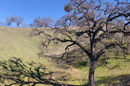
The bucolic laboratory for this study is a catchment dubbed Arbor Creek Experimental Watershed. Located within Blue Oak Ranch Reserve, one of 41 reserves in the UC Natural Reserve System, the site should look familiar to anyone who has traveled through California’s rugged Coast Ranges. High on the western flank of Mount Hamilton, two slopes of ankle-twisting steepness come together in a narrow V. The little valley between them forms the birthplace of an ephemeral creek.
Distinctively different plants
Arbor Creek is a study in contrasts. The sunnier, south-facing slope is furred in bright green annual grasses. The cooler, north-facing slope supports a stand of blue and black oaks, now starting to bud out in leaves.
The compact size of the catchment, together with its dramatic vegetation differences, makes Arbor Creek an ideal study site. “The same amount of precipitation is falling on both slopes, and the subsurface structure is largely the same,” Zimmer says. “This lets us isolate how vegetation may drive differences in the storage and release of water from the landscape.”
However, tracking the fate of that water isn’t so easy. “We don’t have x-ray vision to see the water underground. It’s hard to visualize where the water’s coming from or going,” she says.
A blanket of sensors
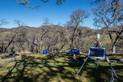
In lieu of Superman powers, Zimmer and her CHI colleagues are deploying a formidable array of instruments. The watershed positively bristles with gauges, meters, wells, and samplers.
The crowns of the hills and both slopes are outfitted with rain gauges. Three Clima-Views, the Swiss army knife of weather stations, are stationed at strategic points. Borehole wells monitor deep groundwater levels, while soil moisture probes track the water content of shallow soils.
Each device is designed to illuminate a portion of Arbor Creek’s water budget. The data they yield will reveal where water is being stored, when the water table fluctuates, and how plants are utilizing this precious seasonal resource.
The benefits of working together
The Arbor Creek research site is relatively new. Zimmer found it after joining the UC Santa Cruz faculty two years ago. At that point, CHI-Freshwater was already planning to conduct intensive landscape studies at Blue Oak Ranch Reserve.
“I toured many different watersheds and experimental forests,” Zimmer says. “The big draw to Blue Oak Ranch was the CHI initiative. I saw a lot of opportunities to leverage and bolster CHI’s objectives through my work.”
Becca Fenwick, program manager for CHI-Freshwater, is equally pleased with this chance to do multidisciplinary science. “The breadth of expertise we now have from the people who are taking part in this project is phenomenal. They all bring different pieces of the puzzle,” says the UC Santa Cruz-based researcher.
The fact that Blue Oak Ranch is managed for research sealed the deal. “The staff here do everything in their power to accommodate our requests and make sure we’re supported. Being at a reserve has influenced our productivity and ability to do research,” Zimmer says.
The partnership has made the science more robust as well. By combining their financial resources, Zimmer and CHI were able to deploy more instruments at the research site. “By combining our resources, we’re able to bolster our ability to observe watershed function in these systems,” Zimmer says.
Calendar of plant thirst
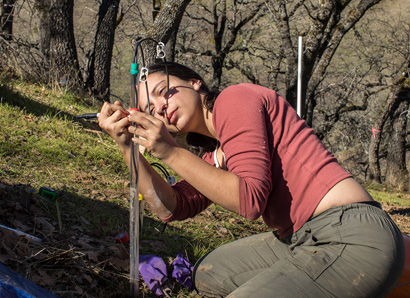
A key part of that budget is consumed by plants, which pull water from the subsurface and release it to the atmosphere. One of Zimmer’s graduate students, Amanda Donaldson, is tracking how plants’ appetite for water varies across the seasons. The out-of-step life cycles of the plants enables her to isolate the appetite of the oaks from that of the grasses.
“Right now, in winter, there are no leaves on the trees. They’re basically sleeping for a couple of months. They’re not taking up water from the subsurface. Versus the grasses, which are green and transpiring. They’re removing water from the first meter or so,” Donaldson says.
As spring wears on, “there will be a time when both the trees and the grasses are transpiring. I want to know how differences in their water use patterns influence subsurface water storage,” she says
By midsummer, the annual grasses have died, and only the trees are transpiring. There’s even a brief point in winter when neither oaks nor grasses are growing.
To quantify the amount of water the trees are transpiring, the team has installed sap flow meters on the trunks of the oaks. On the opposite slope, Donaldson will periodically place a dome over a patch of grass to monitor the rate of photosynthesis.
How water fluctuates at Arbor Creek offers a glimpse into California’s climate future. “If landscapes become hotter and drier, the south-facing slope may be what the north-facing slope will look like in the relatively near future,” Zimmer says.
Oak savannas that become grasslands will also change the amount of water stored in the ground. That, in turn, affects how much water streams carry to human communities downhill.
From moisture sensors to pixel data
Donaldson’s information about plants has a ready customer. The CHI-Freshwater team wants to correlate the water status of the plants with images they’re gathering on the site using drones. They want to know whether signals of moisture in the plants and soils are visible on drone and satellite images.
“If we can understand the mechanics of what’s happening in the ground, and detect that change in remote sensing data, we wouldn’t have to dig pits in soils and put sensors across the state,” says Becca Fenwick, coordinator for CHI-Freshwater. “Instead, we could use the remote sensing data to get that same information.”
The remaining portion of Arbor Creek’s water budget is the moisture absorbed by the hills and trickling down the creek.
Measuring what escapes via the stream is relatively straightforward. To do this, the scientists have installed a white fiberglass chute across the valley’s narrowest point. The water level in the flume indicates the amount of water the creek carries.
But the water that flows down streams isn’t entirely composed of the rain that most recently fell from the sky. In fact, “in any rain event, over 70 percent of the water you see in any stream was already in the soil, and 30 percent or less is actually new water,” says Emilio Grande, another of Zimmer’s graduate students.
Dating the water
Grande is puzzling out when the water in the stream arrived at Arbor Creek. Because that information affects water available to plants, it has a direct bearing on Donaldson’s vegetation research.
“If I know the age of the water when it leaves the system, I can say something about how long precipitation is going to reside within the slope, and how long that water potentially will be available for vegetation,” she says.
Estimating the age of water requires examining its various atomic formulations, or isotopes. Warm storms carry water containing heavier isotopes of hydrogen and oxygen than storms that form in the arctic. Grande periodically takes samples from the stream and from the rain gauges to identify the isotopic signatures of individual precipitation events. Once he knows how the isotopes in rain vary with time, he can use numerical models to figure out how much time it takes rainwater to become the water that is seen in the stream.
After analyzing water from the catchment across a rainy season, Grande can use established formulas to calculate how much was old water already stored in the soil and how much was new precipitation just delivered from a cloud.
Those equations, however, were developed for places with year-round rain. “I’m trying to come up with something that better describes not only Mediterranean climates but also this kind of ephemeral stream,” Grande says. “Potentially we will come up with a new model that can explain the effect of these starts and stops.”
Grande is double-checking this technique by analyzing sulfur and hydrogen isotopes in his rain and stream samples. Sulfur provides more accurate dates for “younger” water, while the hydrogen isotope known as tritium can age water that has lingered underground for more than 60 years.
“I am measuring the tritium in the rain when it falls. I am also measuring it in the water from down there at the flume,” Grande says. “Because I know how fast tritium decays, I can figure out how long has passed for that precipitation water to become stream water.”
Grande’s work using radioactive isotopes to study catchment hydrology is on the cutting edge. The technique has only been practiced in a handful of places by very few researchers.
Grande’s findings lend themselves to predicting water storage functions across California, where more than half of rivers run dry for part of the year. Climate models point to less frequent but higher intensity precipitation in coming decades. Grande’s equations will indicate how well hill slopes can absorb those deluges, or how much flooding is in the cards.
Preparing for the future
“If we know, we can better prepare ourselves by building bigger reservoirs, preparing for longer droughts, and bracing for higher-flow events,” Zimmer says.
The study has already piqued the interest of water resource managers at the Santa Clara Valley Water District. The district, which supplies metropolitan San Jose, is located directly downstream from Blue Oak Ranch. That makes the Arbor Creek findings particularly pertinent for the people of California, Zimmer says. “If you’re trying to develop infrastructure to store or release more water, you need to understand how these systems work, and how watersheds are going to persist in the future.”