For more than a year, we have been gathering feedback as we work on a new Long Range Development Plan. An LRDP is a land use map that designates campus land according to various uses, such as academic and housing. It is not an enrollment plan nor is it a master plan.
What’s in an LRDP?
To undertake this work on designating land use, we are using a test enrollment figure to understand the square footage needed on the campus by 2040—the 20 year horizon for which the LRDP will cover. The test enrollment figure of 28,000 students is reflective of what the campus founders envisioned for the eventual campus size (27,500 students by the year 1990). It also aligns with historical enrollment growth.
To reiterate, this enrollment number is not a mandate for enrollment, but rather a number to help identify impacts of land use at this enrollment capacity. The test enrollment figure is evaluated at three significant points in the LRDP planning process. The first evaluation takes place when a draft land use scenario is selected. The second point of evaluation occurs when the draft LRDP is developed and the environmental analysis begins. The final evaluation occurs when the draft Environmental Impact Report is complete and the LRDP is being finalized to submitted to the Board of Regents for review and approval. We anticipate the plan will be submitted to the Regents in late 2020.
We want to hear from you!
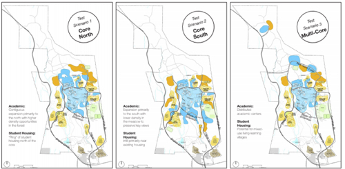
We share with you today three land-use test scenarios that have been mapped. These maps have been developed based on feedback from the online mapping tool, campus and community forums, and discussions with expert working groups and the LRDP Planning Committee. The three test scenarios show academic and student housing land use designations. Also included are possible future employee housing scenarios, which will eventually be incorporated into the land use scenarios.
We are seeking your feedback on these test scenarios as part of the process of further refining these initial ideas that have been developed thanks to your input. We ask that you submit your thoughts using an online Google form.
The form will be open until Dec. 5, 2018.
A briefing document is available online.
This document outlines the various assumptions underlying the approach to the land use test scenarios for academic space and student housing, as well as potential approaches for locating employee housing.
How will we use your feedback?
Your feedback will be we shared with the LRDP Planning Committee, as they work to identify two land use test scenarios. The LRDP Planning Committee is not limited to any one of the three scenarios, but may integrate elements from different scenarios to develop the best land use plan.
In January, the committee will host campus forums to workshop the refined scenarios. We will, again, host community forums to update the broader community on the status of the current planning process and the land use scenarios.
By the end of the academic year, we will identify a preferred land use scenario to analyze. The testing and analysis that we do at that time will be informed by the ideas and concerns expressed by campus constituents and the community at large. Analysis will be undertaken on a variety of topics, including traffic, water, and housing.
Your feedback is important. To ensure that we can be as inclusive as possible, we have extended the LRDP development timeline. We truly hope that you will take the time to offer us your feedback on the campus’s land use plan out to 2040.


