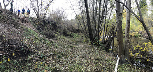
The entrance road to Henry Cowell Redwoods State Park crosses the San Lorenzo River and winds through a broad flat meadow. To Noah Finnegan, a geomorphologist who studies rivers, something about this landscape doesn’t look quite right.
“The river is really deep below the floodplain. That meadow at the entrance is the historical floodplain, and most natural rivers flood out of their channel every one to two years, but the San Lorenzo never floods in Henry Cowell,” said Finnegan, a professor of Earth and planetary sciences at UC Santa Cruz.
It was clear to Finnegan and his students that at some point in the past, the San Lorenzo River cut down into its channel and abandoned the floodplain. So they set out to determine when that happened and why. Their findings, published in December in the journal Earth Surface Processes and Landforms, connect this dramatic change in the river’s behavior to logging practices in the Santa Cruz Mountains in the 1800s.
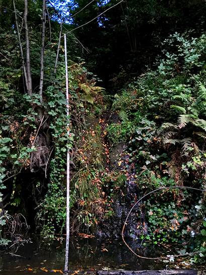
The researchers determined that the river is about 2 to 4 meters (6.5 to 13 feet) below where it would be if it were in equilibrium with the floodplain. Records from the U.S. Geological Survey’s streamflow gauge in Felton show that the river has risen over its banks only twice since 1987—in February 1998 and February 2017—and neither event involved widespread flooding in this area.
To understand when the deepening of the channel occurred, the researchers used radiocarbon dating.
“We were able to find charcoal in the floodplain sediments that could tell us when the material was deposited,” said William Chapman, a UCSC graduate student who led the study. “The latest dates we got from radiocarbon dating were between 200 and 400 years ago, so the river was still connected to its floodplain in the 1600s and probably into the 1800s.”
Clearcut logging was widespread in the Santa Cruz Mountains in the 1800s and early 1900s, bringing dramatic changes to the landscape. One common effect of logging is to increase erosion rates in the watershed by removing vegetation that holds soil in place, causing rivers and streams to become choked with excess sediments and silt. But this would raise the bed of the river rather than cutting a deeper channel.
Many common practices employed during the early days of logging, however, would lead to a deeper channel. Rivers were often used to transport logs, so the channel would be scoured by logs dragged along the bottom and the streambed would be cleared of any debris or logjams that might have slowed the flow of water. Loggers sometimes built “splash dams” to hold back water and then let it go all at once to move logs downstream.
A key factor in a river’s behavior is the balance between its “transport capacity”—how much sediment the river can carry during high flows—and the supply of sediment entering it from the surrounding landscape. If the sediment supply exceeds the transport capacity, the river will deposit sediments and elevate its bed. But if the transport capacity exceeds the sediment supply, the river will begin to cut down into its bed, deepening the channel in a process called “incision.”
“We don’t know for sure what logging practices were used in the Felton area, but anything that simplifies the channel, like skidding logs through the channel or pulling out logjams, leads to the river transporting sediment more efficiently,” Finnegan said. “When you change the hydraulics to move sediment more efficiently, the river will start to dig down, mining its own bed.”
A 2015 study of another watershed in the Santa Cruz Mountains north of Santa Cruz reported similar findings. Deep incision of Pescadero and Butano Creeks was attributed to well-documented historical logging practices, including log skidding in the channels and splash damming.
The abandonment of the floodplain has ecological consequences for species that use floodplain habitats, including salmon and steelhead. Now that the river has cut such a deep channel, however, there’s not much that can be done to restore it to the old floodplain. The river seems to be stable now, and in some places it appears to be forming a new floodplain below the old one.
“The river is where it wants to be now,” Chapman said. “You can’t reverse the incision of the river, but at that lower level it will erode the older banks to create a new equilibrium floodplain that could offer habitat for floodplain species.”
Finnegan said he has learned a lot about the history of the San Lorenzo Valley while studying the geomorphology of the river. He learned, for example, about a flume that was built to transport logs and a large gunpowder mill that operated on the banks of the river in the Paradise Park area, traces of which can still be seen.
“What’s interesting to me is the intersection of history and archaeology and Earth science,” he said. “We have a tendency to take for granted how things look in the natural world, but there are huge legacy effects of land use decisions made decades and centuries ago that still affect rivers today. The forests have grown back, so it’s hard to appreciate how extensively this area was logged and the impacts that had.”
In addition to Chapman and Finnegan, the coauthors of the paper include Allison Pfeiffer at Western Washington University and SeanPaul La Selle at the U.S. Geological Survey. This work was funded by UC Santa Cruz and the UCSC Department of Earth and Planetary Sciences.