Campus News
Tracking data used to identify biodiversity hot spots in Southern Ocean ecosystems
An international team of scientists used electronic tracking data from birds and marine mammals to identify areas of ecological significance in the waters around Antarctica.

Ecosystems in the Southern Ocean around Antarctica face growing threats from climate change and fishing pressure, but identifying areas in need of protection is challenging.
A paper published March 18 in Nature (together with a companion data paper in the journal Scientific Data) describes a novel solution to this problem, using electronic tracking data from birds and marine mammals.
“We identified common areas used by multiple species, which allowed us for the first time to evaluate how well Marine Protected Areas are serving the entire community of species in the Southern Ocean,” said coauthor Luis Huckstadt, an assistant researcher in the Institute of Marine Sciences (IMS) at UC Santa Cruz.
Animals go to places where they find food, so identifying areas of the Southern Ocean where predators most commonly go reveals where their prey can be found. For example, humpback whales and penguins will go to places where they can feed on krill, whereas elephant seals and albatrosses go where they can find fish, squid, or other prey. If all these predators and their diverse prey are found in the same place, then this area has both high diversity and abundance of species, indicating that it is of high ecological significance.
The project was coordinated by the Scientific Committee for Antarctic Research (SCAR), with support from the Center for the Synthesis and Analysis of Biodiversity (CESAB) in France and the World Wildlife Fund–UK.
As members of SCAR’s Expert Group on Birds and Marine Mammals, Huckstadt and coauthor Daniel Costa, professor of ecology and evolutionary biology and director of the IMS, were part of the core team that planned and carried out the study, engaging with an extensive network of Antarctic researchers to assemble existing Southern Ocean predator tracking data.
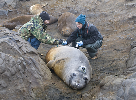
Costa and Huckstadt contributed their own tracking data from their studies of Weddell seals, crabeater seals, and Southern elephant seals, and coauthor and IMS researcher Ari Friedlaender contributed data on humpback whales. Co-first author Ryan Reisinger played a principal analytical role in the study while a researcher at CESAB in France, and is currently a postdoctoral researcher in Friedlaender’s lab at UC Santa Cruz.
After careful validation of the predator tracking data, the combined result was an enormous database of over 4,000 individual animal tracks from 17 species, collected by more than 70 scientists across 12 national Antarctic programs. This database is now available for public download.
Even this impressive database does not directly represent all Southern Ocean predator activity, because it is impossible to track every species from all their breeding colonies. Simple mapping would therefore provide a biased representation of animal distribution. To overcome this, sophisticated statistical models were used to predict the at-sea movements for all known colonies of each predator species across the entire Southern Ocean. These predictions were combined across the 17 predator species to provide an integrated map of those areas used by many different predators with diverse prey requirements.
The most important of these areas—called “areas of ecological significance”—are scattered around the Antarctic continental shelf and in two wider oceanic regions, one projecting from the Antarctic Peninsula across the Scotia Sea, and another surrounding the sub-Antarctic islands in the Indian sector of the Southern Ocean.
Marine Protected Areas (MPAs) are a crucial tool in the conservation management toolbox. Existing and proposed MPAs in the Southern Ocean are mostly found within the areas of ecological significance, suggesting that they are currently in the right places. Yet when using climate model projections to account for how areas of important habitat may shift by 2100, the study found that existing MPAs with their fixed boundaries may not remain aligned with future important habitats.
“The existing and proposed MPAs do a remarkable job of protecting these regions,” Costa said. “While the habitats will shift with climate change, a substantial amount is likely to remain within protected regions.”
According to the authors, dynamic management of MPAs, updated over time in response to ongoing change, will be needed to ensure continued protection of Southern Ocean ecosystems and their resources in the face of growing resource demand by current and future generations.